Six Daytrips from Tokyo, Japan
During my one-month study abroad in Tokyo, Japan in February 2025, I had the opportunity to explore outside of Tokyo during weekends and holidays. I did six sightseeing-focused daytrips which should especially appeal to folks interested in nature and hiking. This post is extremely long; be warned! You can view the locations of each day trip on this Google MyMaps.
Mt. Takao
Mt. Takao was a logical first daytrip destination as a nature getaway from the hustle and bustle of central Tokyo. It is easily reachable within 1-1.5 hours from central Tokyo by subway to the Takaosanguchi Station; in fact, I loved it so much I went twice.
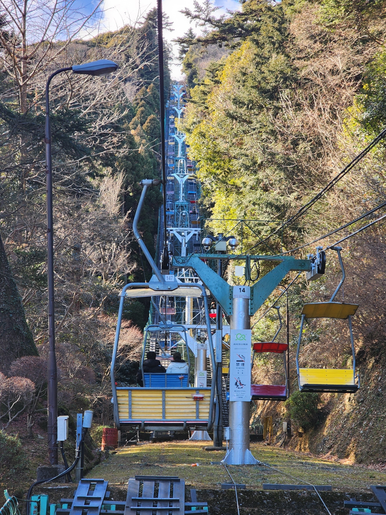
Once arriving, a well-marked path with shops selling treats and various hiking goods leads toward the entrance of the mountain itself. There are several options for going up the mountain. Multiple hiking trails of varying difficulties traverse around and up the mountain; alternatively, a cable car ride and chair lift brings tourists roughly halfway up the mountain, and the rest of the way can be hiked. Note that the chair lift closes fairly early at 4 PM from December to April and 4:30 PM the rest of the year.
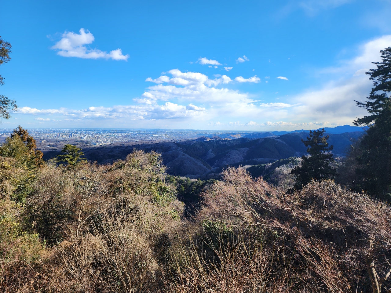
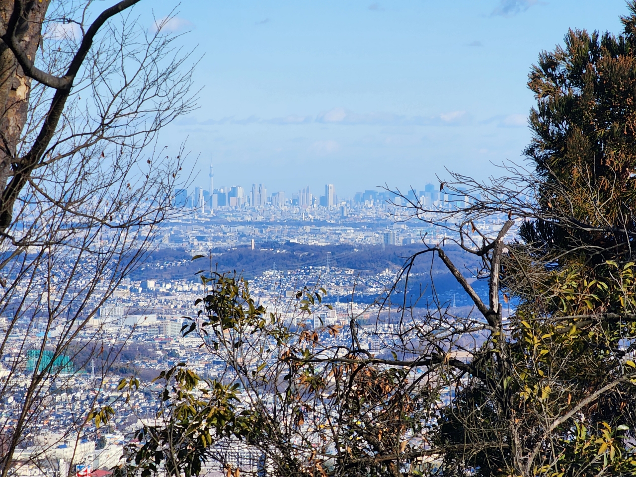
My first visit was a spontaneous decision I made after visiting a friend in the morning, and I arrived shortly after 2PM. As I wanted to get out before the early winter sunset, I decided to take a round trip on the chair lift. The chair lift is actually quite relaxing and enjoyable, and feels quite safe with all the netting below. The final stop of the chair lift spits passengers out on Trail 1 with great views of the Tokyo and Yokohama skylines on a clear day.
Continuing along Trail 1, a split in the road leads to either a 108-step stairway (Otoko-zaka) or a sloped road (Onna-zaka), which both re-join and lead to the Yakuo-in temple. This is a also a great spot to receive handwritten goshuin , a stamp which serves as proof of prayer and protection. If you don’t have a book for goshuin yet, the books sold here have unique maple leaf designs.
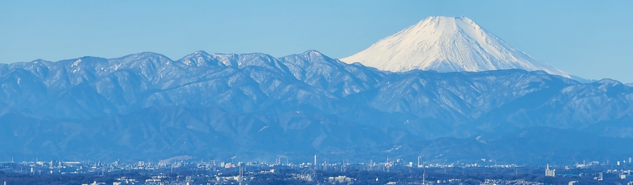
After a little more walking the trail reaches the summit with a rewarding view of Mt. Fuji that is best viewed on clear morning days. As it was already 3 PM when I reached the top, the peak of Mt. Fuji was partially obscured by clouds.
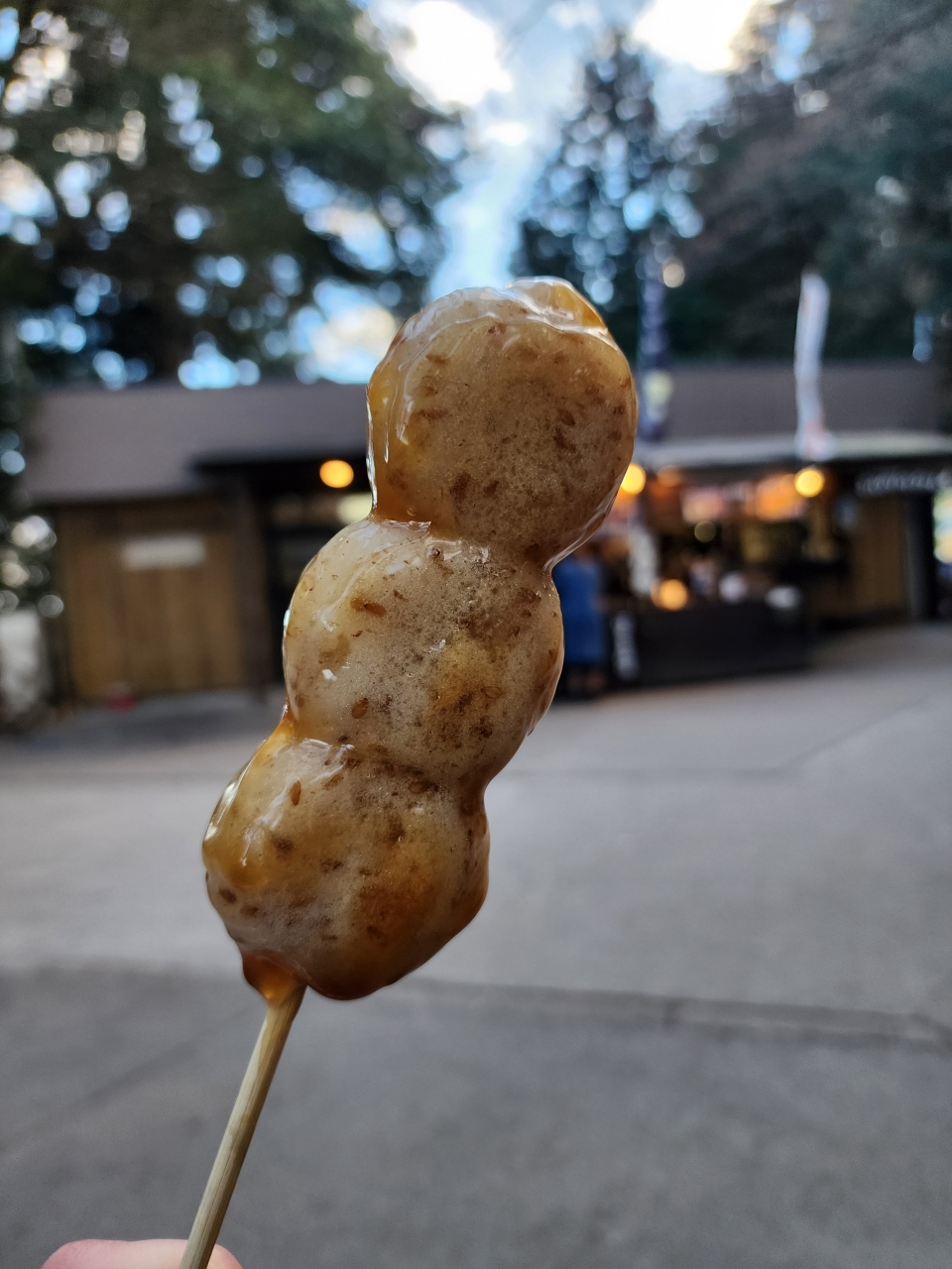
During my descent I also grabbed one of Mt. Takao’s delicacies, sesame dango (goma dango), from Gomadokoro Gongenchaya. These dango are a warm treat during winter with the sesame-infused mochi covered in a slightly salty sauce.
On my second visit I hiked up Trail 6 within an hour to the summit, and then hiked down via Trail 4 and then Trail 1; this is great for folks who enjoy hiking or want a weekend exercise/training location. My second visit fell on the long holiday weekend of the Japanese Emperor’s Birthday (February 23rd), so the mountain was much more crowded than usual. Again, while I visited during clear skies in the morning, by around 12/1PM the top of Mt. Fuji was already obscured.
Fuji Five Lakes
In search of better views of Mt. Fuji (other exchange students gave me the nickname “Fuji Lover”), I opted to visit Fuji Five Lakes (Fujigoko) located at the base of Mt. Fuji. Getting there takes 2-3 hours from central Tokyo depending on whether you take rail or bus. Reserving bus tickets can be quite difficult depending on the season, and buses were near-full when I tried to book tickets around three days advance during Chinese New Year. Bus reservations can be made on highwaybus.com, with buses departing either Shinjuku Expressway Bus Terminal (Busta Shinjuku for short) or Tokyo Station. Both rail and bus public transportation options drop passengers off at Kawaguchiko Station, located close to the namesake Lake Kawaguchi. A local Sightseeing Bus network transports passengers to popular destinations around most of the lakes. However, getting around is best done by rental car, which I opted for through Budget Rent-A-Car’s Fujikawaguchiko branch.
After boarding an early bus and picking up my rental, my first stop was Arakurayama Sengen Park, famous for the stock photo picture of Mt. Fuji with cherry blossoms and Chureito Pagoda. The parking lot was nearly full at 10 AM, and I had a real challenge backing all the way into my spot as a newbie left hand driver (note that by the time I left at around noon there were plenty of spots). As expected the pagoda viewpoint was full of people. However, just a bit further up the hill there is a much quieter viewpoint of Mt. Fuji. This side of Mt. Fuji is best appreciated with the morning east-facing sun.
On my way down I got a goshuin from the Arakura Fuji Sengen Shrine before moving on to my next destination, Oishi Park. Located on the north shore of Lake Kawaguchi, the park is best known for its flowers and grasses that provide a great foreground to Mt. Fuji. I did not spend much time here as The park is quite touristy and was full of people when I visited, though you can get some nice pictures of kochia bushes (which turn red in autumn) with Mt. Fuji in the background.
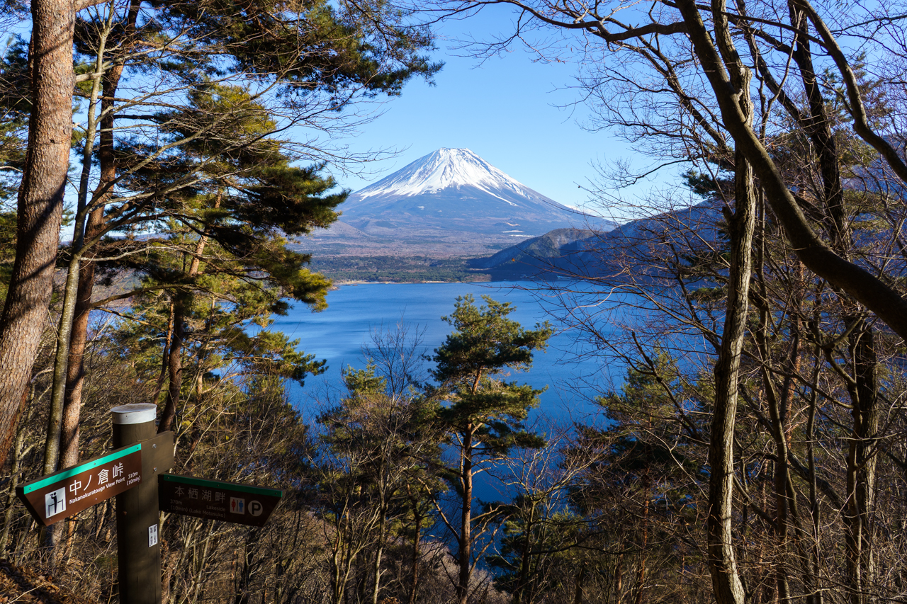
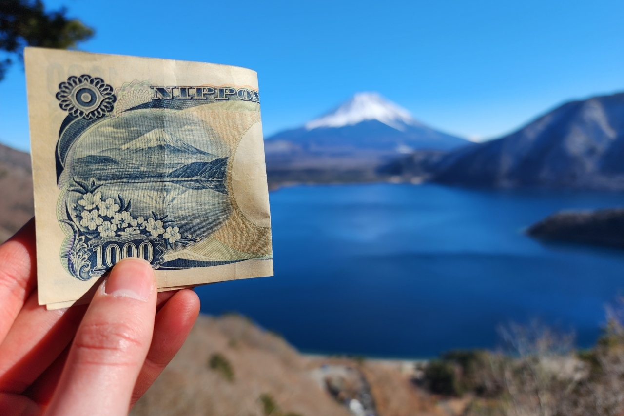
I then continued along the northern shore of Lake Kawaguchi before continuing westward to Lake Sai, stopping briefly here and there for some pictures, and eventually making my way to Lake Motosu. Lake Motosu is the western-most of the Fuji Five Lakes and has few tourists in comparison to the others. I snagged a spot at the parking lot adjacent to the Lake Motosu Observation Park, notable for its view of Mt. Fuji that was displayed on the previous edition of the 1000 yen bill before hiking up the trail to the Nakanokura Pass Viewpoint. Although the trail has a slightly steep incline, the top can be easily reached in under 30 minutes and is definitely worth the trek.
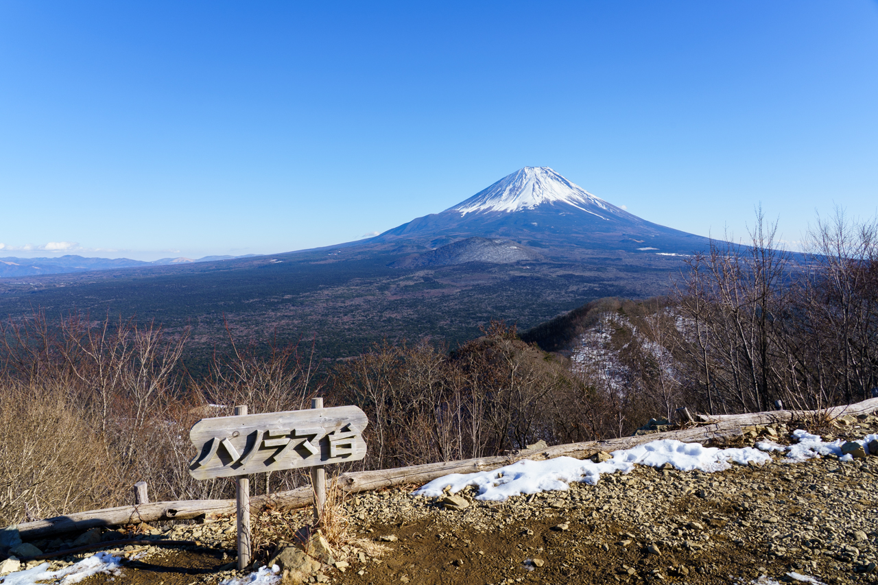
Looking on Google Maps I found another view of Mt. Fuji in the vicinity from a viewpoint called Lake Shoji Panorama-dai (not to be confused with the Lake Yamanaka Panorama-dai, 山中湖パノラマ台) and proceeded to hike there. Although it took me much longer than I expected (approx. 40 minutes one way from Nakanokura Pass Viewpoint), the view is definitely worth it as you get a view over the Aokigahara Forest without any other obstructions. I encountered only one other person during this hike along the whole way.
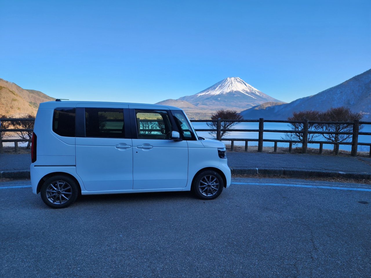
As the sun was quickly starting to set at this point, I scurried back to the parking lot and snapped one last photo with the cute Honda N-Box kei car that I drove around in before returning it. In case you didn’t know, kei cars are a very compact, fuel-efficient type of car in Japan. The N-Box has lots of modern features that I appreciated, like USB-C charging, sliding doors, backup camera, and in-car GPS navigation, though not all kei cars are that tech-savvy. Especially as a beginner of left-hand drive it felt comforting to have extra space on both sides. Some people online complain about them having insufficient power, and while that might be true for very mountainous areas, I didn’t have a problem around Fuji Five Lakes.
I did consider stopping for the local delicacy, called ho-to (ほうとう), while I was driving, but didn’t have the time. Maybe next time!
Okunikko and Nikko
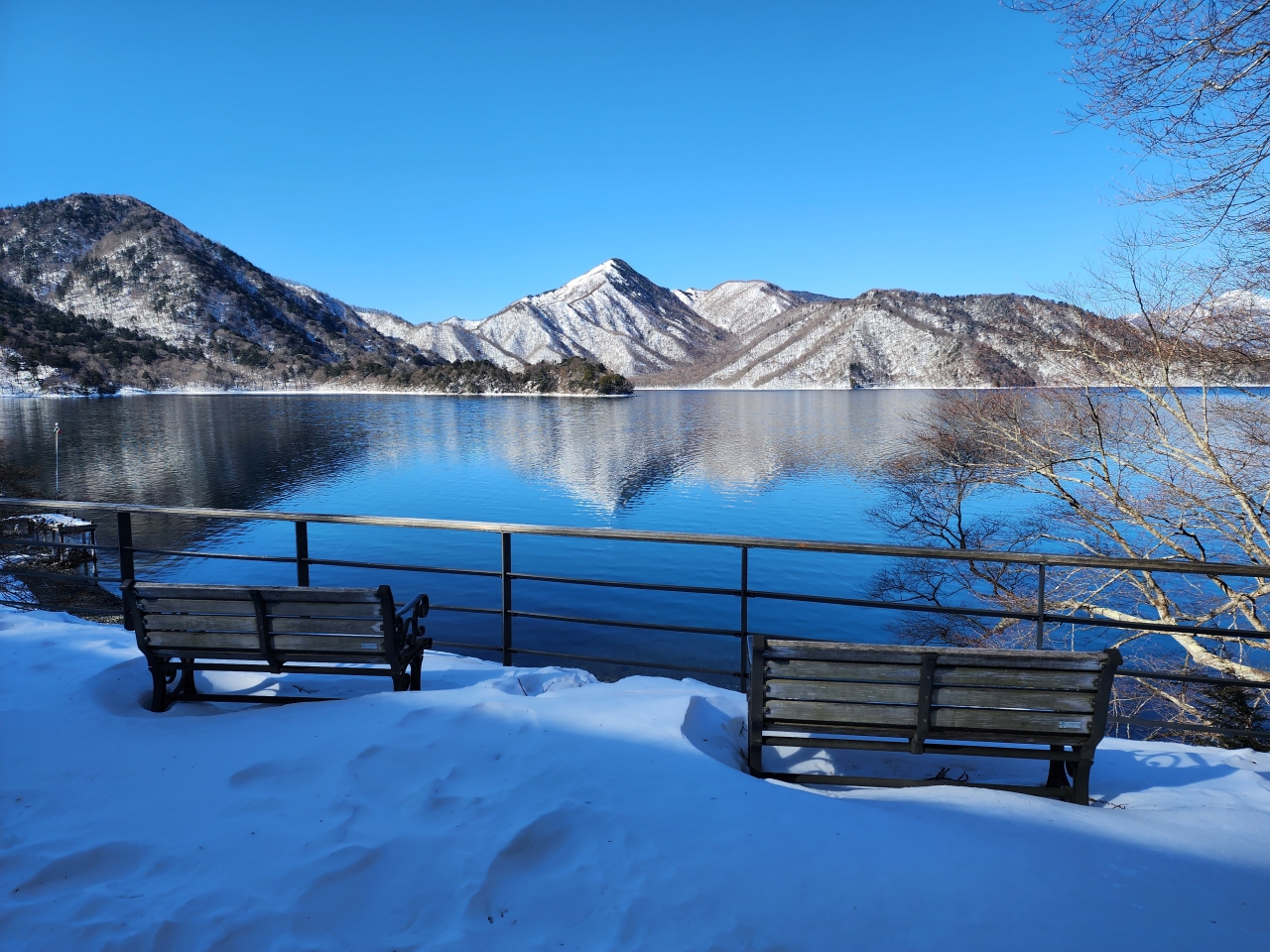
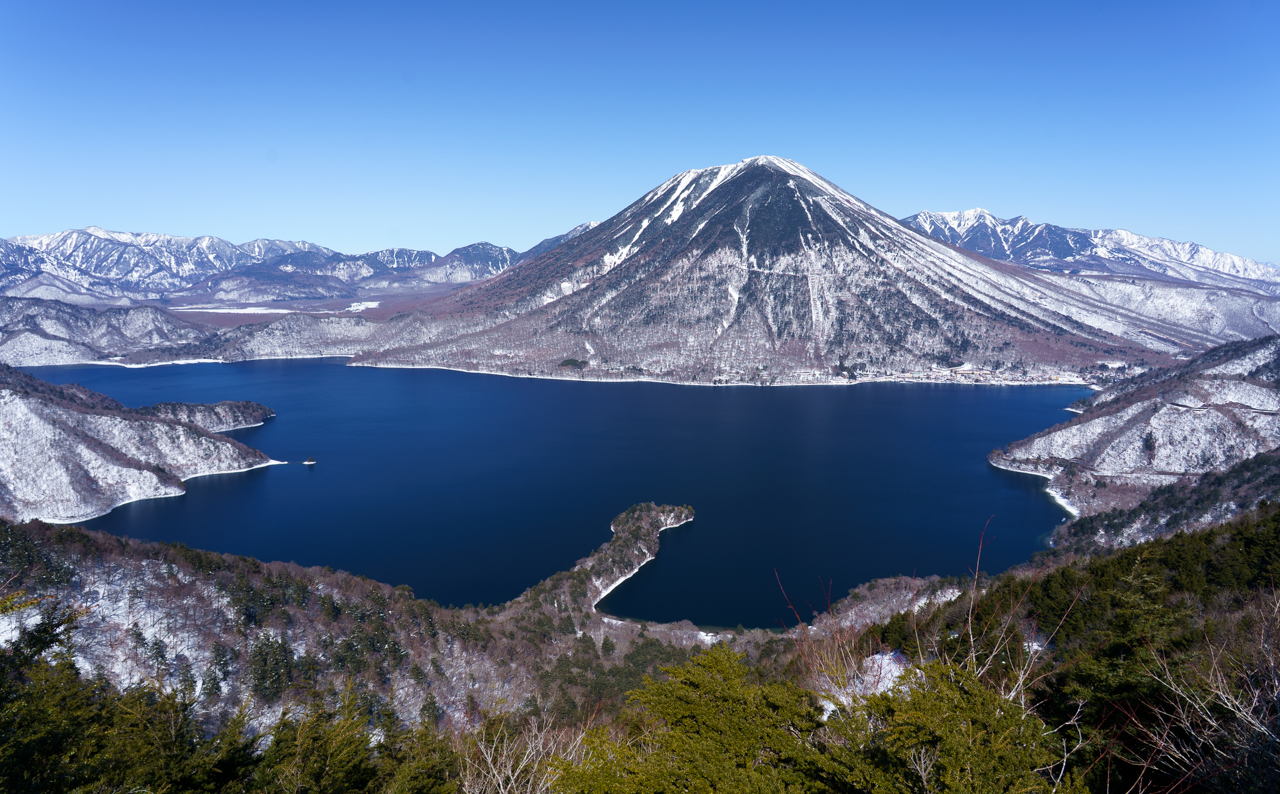
Nikko is a well-known daytrip destination outside of Tokyo. While most visit the Shrines and Temples of Nikko UNESCO site, I found a great hiking spot in an area known as Okunikko, which literally means “Deeper Nikko.” I set my sights on the hike to Mt. Hangetsu Observatory with its stunning view of Mt. Nantai and Lake Chuzenji. During the warmer months of the year (mid April to October) there is a road that allows cars and, during peak leaf-peeping season, buses to get within 30 minutes of the observatory. However, this road is closed in the winter, so the observatory can only be accessed by hiking in the winter.
Getting to Nikko is extremely convenient from Tokyo via any of the stations served by Tobu Railway. I purchased the Nikko Pass All Area, which gives base train fare from Tokyo to Tobu-Nikko Station, the central hub for transportation throughout the tourist sites in Nikko, as well as unlimited bus rides in Nikko. On top of this I also purchased a limited express (tokkyu, 特急) ticket upgrade that greatly shortens the travel time from around 3 hours to a litle more than 1.5 hours.
Getting to the start of the hike requires a little bit more planning. The earliest way to start is as follows. After departing on the first limited express train, I arrived at Tobu-Nikko Station at 8:25 AM before transferring to the 8:35 AM bus bound for Chuzenji Temple. The bus ascends the famous Irohazaka Winding Slope all while gaining elevation before arriving at the Chuzenji Onsen bus terminal at 9:20 AM. From here, I walked in the direction of Chuzenji Temple along Tochigi Prefectural Route 250 before arriving at the lakeside trail that marks the start of the hike. A map of the trail I walked can be followed here.
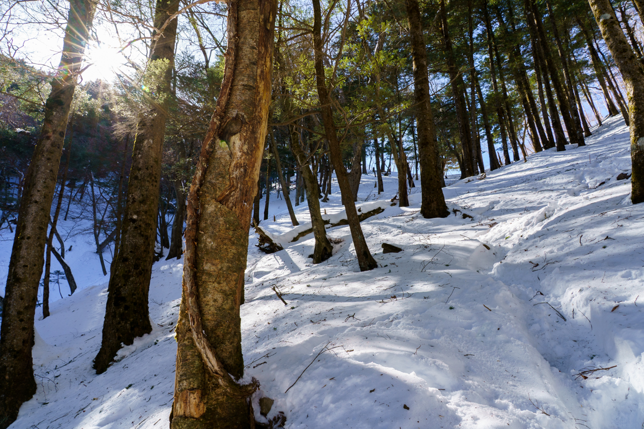
As I trudged along the lake path, which I slipped on multiple times (I should have brought spikes, and as I would realize later, shoe covers), I unexpectedly encountered some very nice looking houses. These houses are in fact the former villas of the British and Italian embassies. Unfortunately they weren’t open during the winter while I visited.
Continuing on, the trail branched leftward to begin the ascent up Mt. Hangetsu. It had apparently snowed here perhaps a half a week ago, and so there was a foot or two of snow in many places (or even more)—far too deep to be hiking without shoe covers, waterproof boots, or snow shoes. Despite attempting to step within the tracks of earlier hikers, snow began to accumulate in my shoes, and I thought about turning back multiple times. It felt like hiking up sand, which made the already rather steep hike up the mountain even steeper.
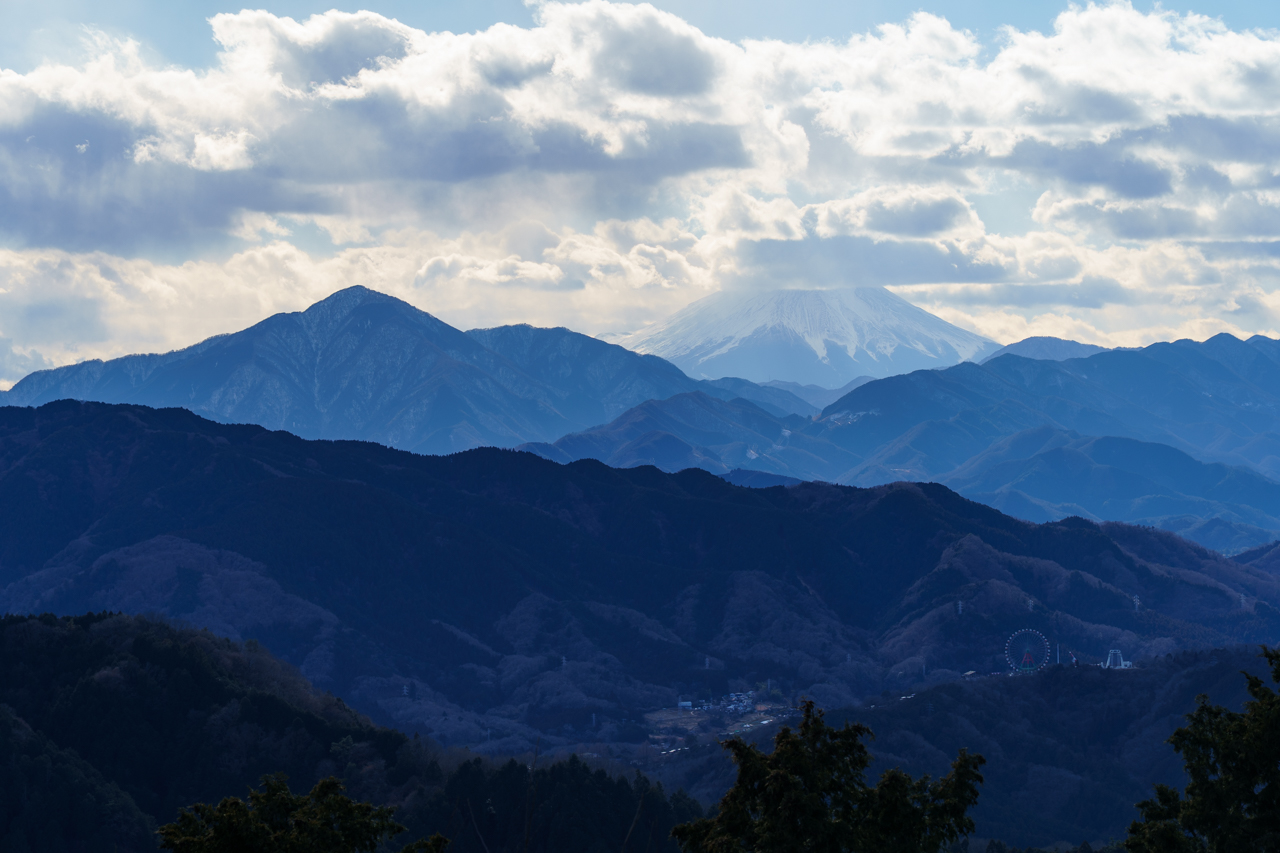
Eventually I reached a bifurcation, which finally gave me a rewarding view of the surrounding snow-capped mountains. Remarkably, it was so clear across the entire Kanto Plain that you could see Mt. Fuji peeking over the neighboring mountains—an astonishing 164 km (102 mi) away! (For those curious I used this cool website to calculate the distance.)
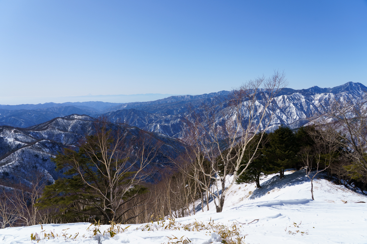
I was really encouraged by this view, and so I continued my hike upwards. The last portion was by far the steepest (what felt like 30-45 degree incline in some places), and in the snow without spikes, hiking sticks, or any sort of traction, I found myself sliding down the slope. Again I seriously considered turning back, but after struggling around in the snow and going in circles for some time, I finally pushed my way up to the observation deck. And what a view!
A couple of other hikers continued to reach the actual summit of Mt. Hangetsu. A passing hiker on their way down told me that the going up there was pretty rough and that there was no view, so I decided against climbing further, especially given my wet shoes, and decided to head back. Going down was actually pretty fun; since my shoes had no traction and the snow was a little slippery, I ended up sliding and clomping my way down the snow. On my way down I also bumped into a deer, which didn’t seem to mind humans at all.
The overall hike took me 4.5 hours, including 1.5 hours of rest time. Along my way back, I stopped by Lake Chuzenji’s namesake temple dedicated to Tachiki Kannon, a very tall wooden statue that was apparently swept away in a landslide and then miraculously washed up at shore again. This is one of the oldest temples in the area. Photos aren’t permitted inside but it’s worth the 500 yen entrance fee to take a peek.
I made my way back to the Chuzenji Onsen bus terminal before heading back to Nikko to take a look at the shrines. Although there wasn’t much time left, I was able to look around Nikko Toshogu, the most famous of the shrines as it’s where the shogun Tokugawa Ieyasu is buried. The shrines here are much more impressive than basically all that you’ll find in Tokyo.
To be honest, I don’t really remember much about looking through the shrines because I was quite exhausted from my hiking until this point, but it was definitely worth a visit! Overall hiking Mt. Hangetsu was one of the best hikes I’ve ever done. You can see my hike data here.
Kamakura
Kamakura is a well-frequented daytrip spot known for its many temples and shrines. It’s also a great place to collecto goshuin. Kamakura can be easily reached from Tokyo on JR Lines.
As I was now a certified Mt. Fuji enthusiast, I began my trip by heading toward Cape Inamuragasaki, just a short walk away from the Inamuragasaki Station on the Enoshima Electric Railway. Despite the clear weather forecast for this day and my morning arrival, I was presented with a more common view of Mt. Fuji which was slightly obscured by clouds.
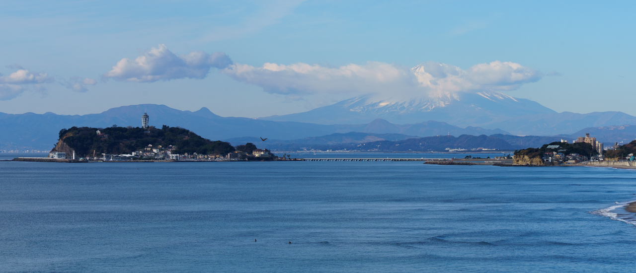
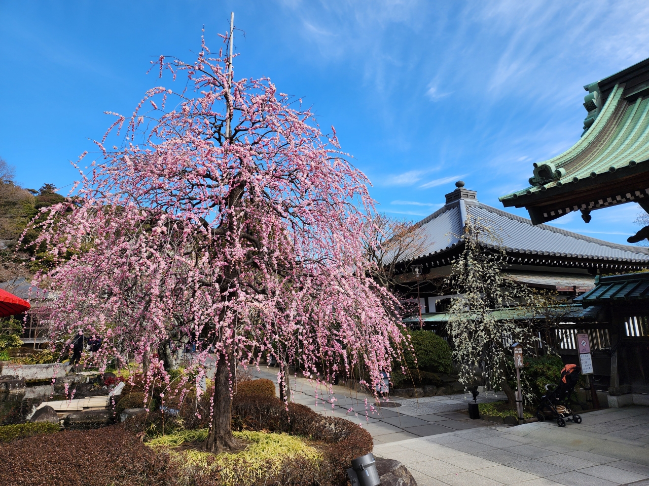
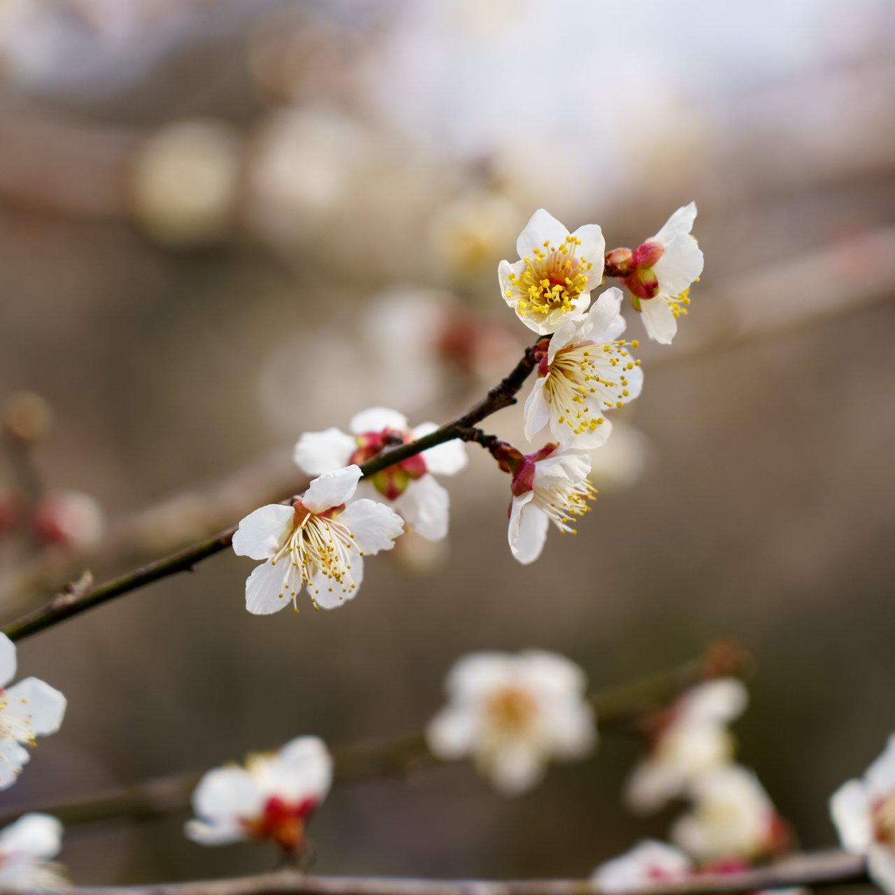
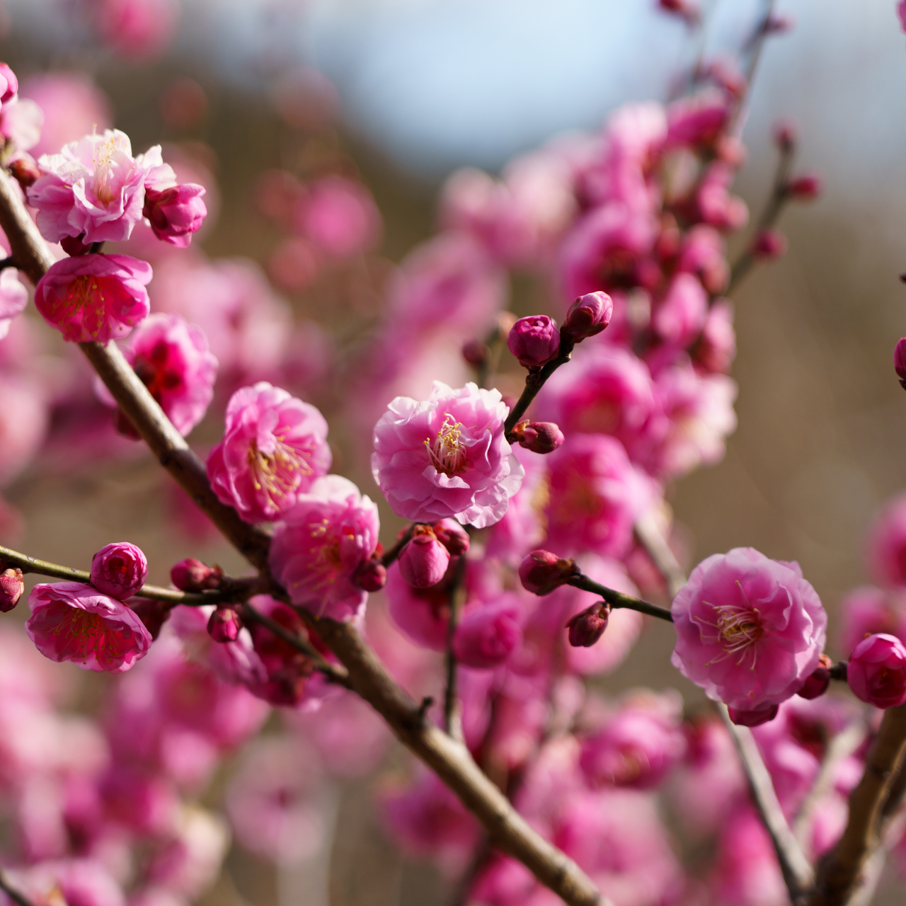
Next I decided to take a leisurely walk along the coast while heading to my next destination, Hasedera, which is a really nice Buddhist temple. Although this one has an entrance fee, it is well worth it as the grounds are quite large, and you can even get a view of the coast from up top or the restaurant on the temple grounds. Pro tip: although March and April are flocked with tourists arriving for cherry blossom season, mid February to early March is peak time for plum blossoms, which in my opinion are just as beautiful.
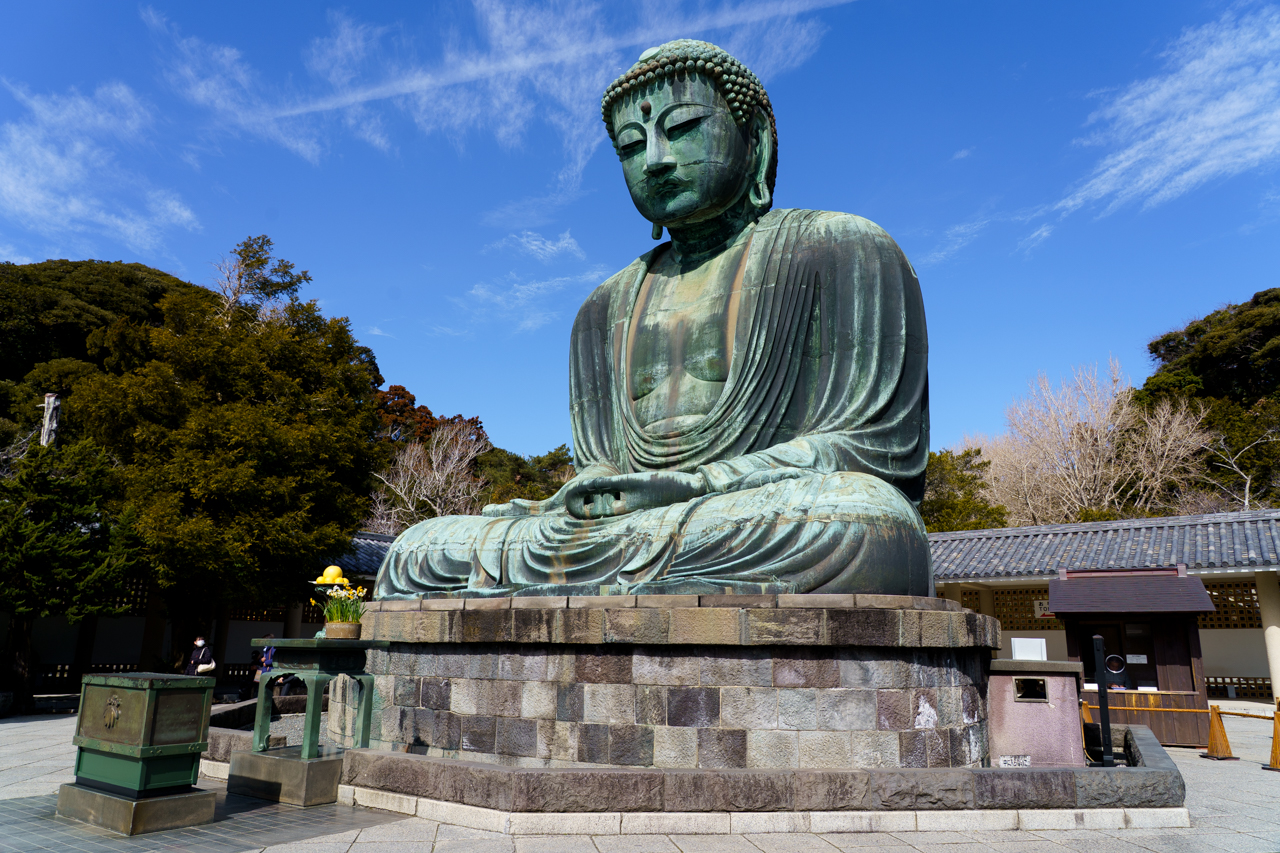
Next I headed up the road for one of Kamakura’s most famous attractions, the Great Buddha at Kotoku-in. You can pay an extra 50 yen to go inside the Buddha itself.
I was hungry at this point so I backtracked to the nearby Hase Shokudo for some shirasu rice bowls, a local delicacy. The slightly salty fish contrasts well with the sweet and fluffy rice. After this, I decided to get my hiking in for the day by heading toward the Daibutsu Hiking Trail. These felt more like small walking trails through the woods, but it served as a convenient shortcut to my next destination, Zeniarai Benten Shrine. This shrine’s gimmick is that you get to wash your money for good luck and fortune. I waived out of having soggy bills, though I did give my change a quick cleansing.
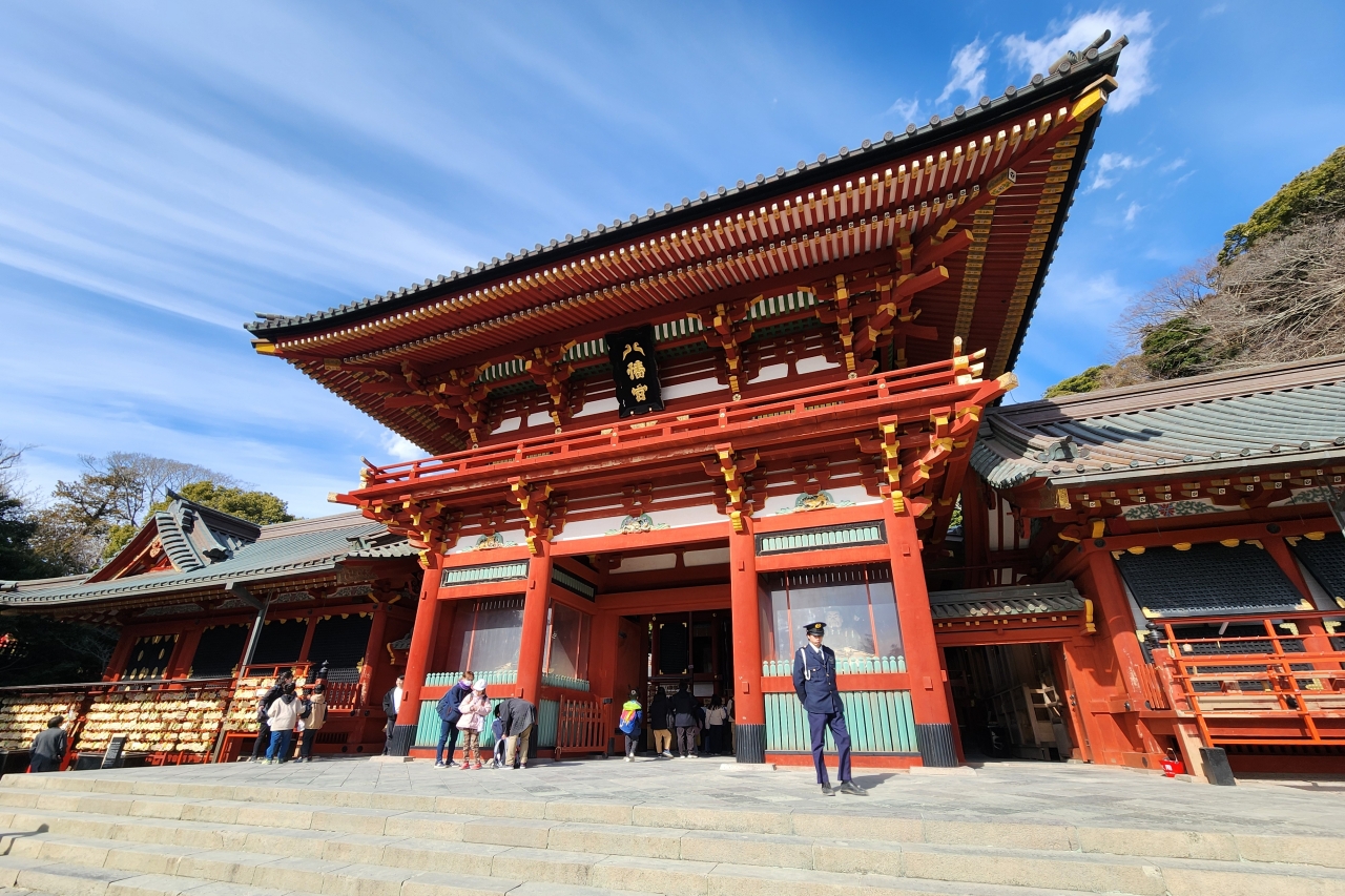
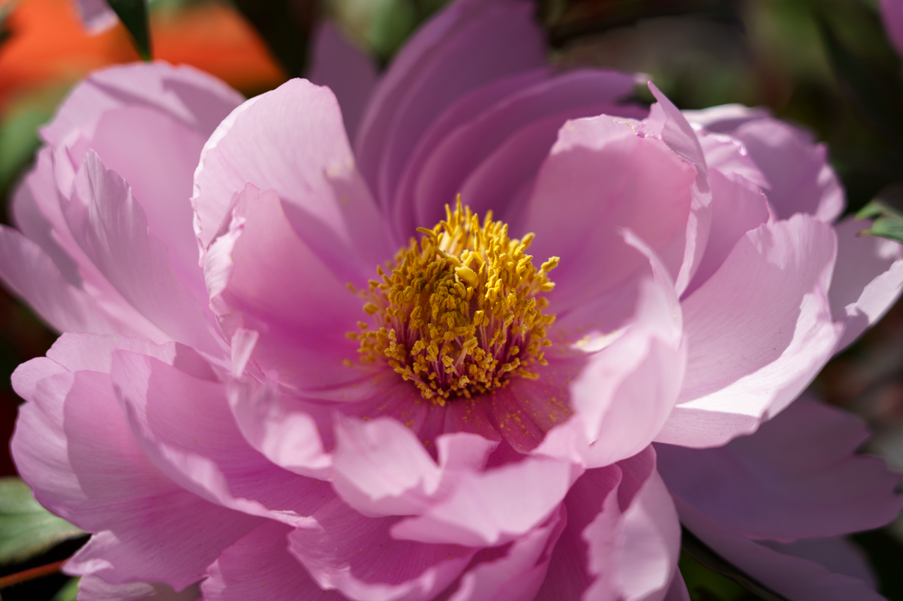
Continuing on the forested trails, I crossed through Genjiyama Park to descend down Kewaizaka Pass, which is one of Kamakura’s Seven Passes in and out of the naturally walled city. I then headed toward Tsurugaoka Hachimangu Shrine, located at the center of Kamakura. Another pro tip: there are peony flowers that bloom in the winter around mid-February, and in addition to the winter peony garden at Tokyo’s Ueno Toshogu Shrine, there is also a large peony garden located here.
Lastly, I grabbed some matcha ice cream on Kamakura’s biggest shopping street, Komachi-dori, before doing one last temple run. I looked at temples close to Kamakura Station and decided on Myohon-ji, roughly a 10 minute walk. This temple is not very touristy at all and feels very secluded. You can get some quiet away from the crowds here.
Overall my day trip here was pretty relaxed and slow-paced. You can also consider adding Enoshima to the itinerary for a whole day experience.
Mt. Tsukuba
Although I was in no shape to climb Mt. Fuji (and even if I was, it’s not open to the public in February), Mt. Tsukuba is said to be Mt. Fuji’s eastern counterpart. It can be reached via taking the Tsukuba Express from Tokyo and then transferring to the Tsukubasan Shuttle Bus. I bought the Mt. Tsukuba ARUKIPPU which includes both train and unlimited bus rides. While many hikers get off at Tsukubasan-jinja-iriguchi, I opted to get off at the last stop, Tsutsujigaoka, to avoid backtracking. I began hiking on the Otatsu-ishi Trail.
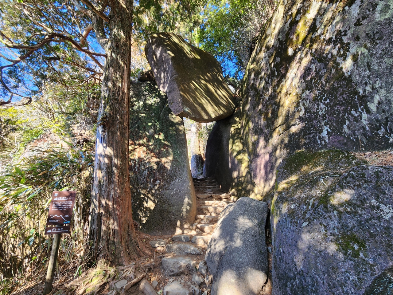
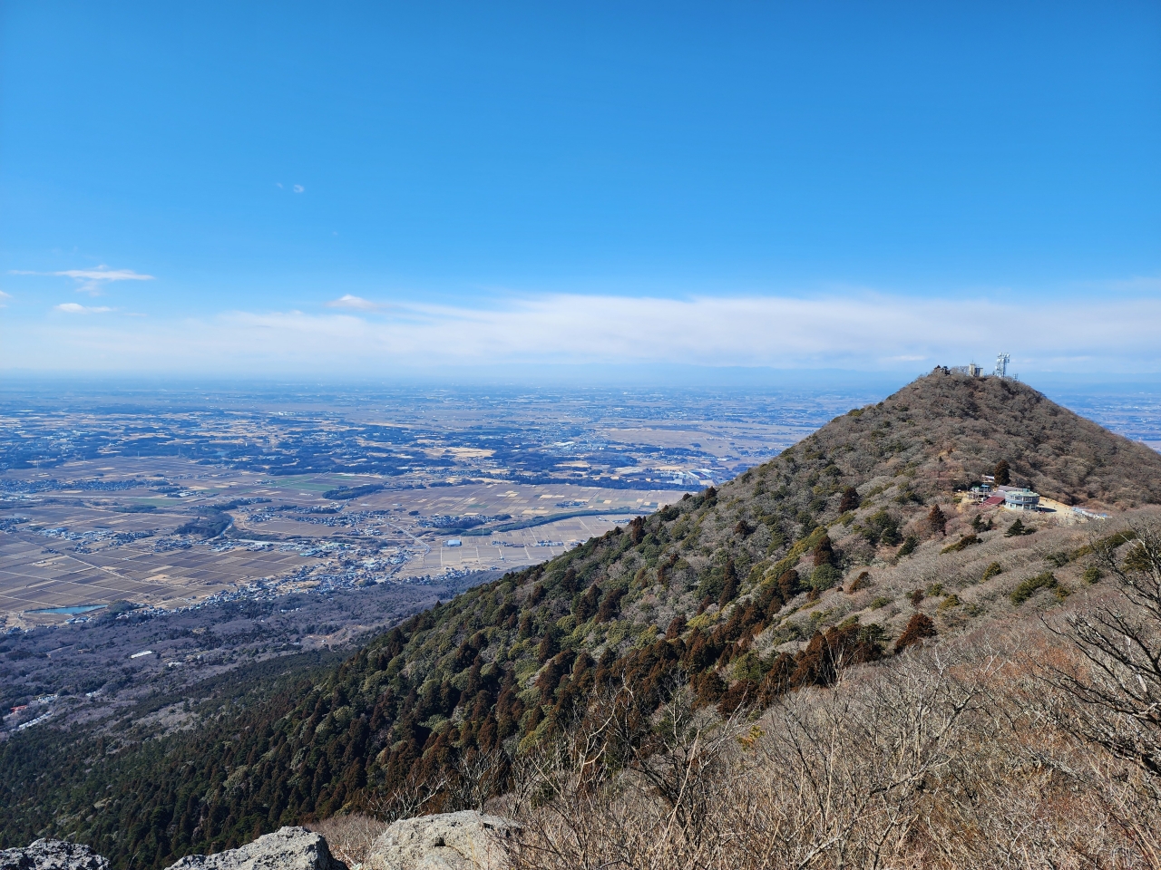
Hiking up from Tsutsujigaoka has its benefits. For one, as Mt. Tsukuba is surrounded by flat terrain, you get great views of the Kanto Plain and Tokyo within 5-10 minutes of beginning the hike. The second benefit is that it goes directly to some very interesting rocks. Officially called the “Strange Rocks and Bizzare Stones” of Mt. Tsukuba, some of which are detailed here, many rock formations on this mountain range from “that’s impressive and cool” to “that’s just a random rock, they were definitely tripping on something.”
After critiquing many more dubious stone formations, I reached the eastern summit of Mt. Tsukuba, Mt. Nyotai (the “female” counterpart to the other peak, Mt. Nantai). Don’t forget your goshuin-cho because they have a priest who will write goshuin!
Surprisingly, Mt. Tsukuba is also one of Japan’s Hyakumeizan, or 100 Famous Mountains, and there’s a plaque on top of Mt. Nyotai to commemorate this. The list of Hyakumeizan includes Mt. Fuji and other tall mountains like Tateyama, but is rather arbitrary.
After a brief stop at Mt. Nyotai I continued along the ridge before ascending Mt. Nantai. You will see the shops selling gifts related to the gama toad (i.e. Japanese common toad). There are apparently frogs living all over the mountain and they make a vaseline-type product from them called gama no abura (ガマの油). At Mt. Nantai you can also get a goshuin.
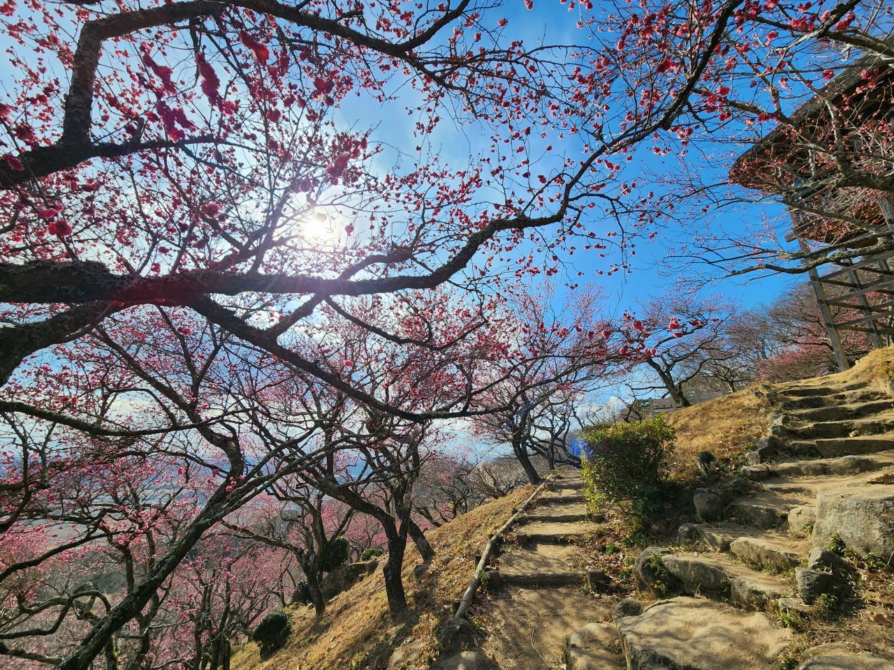
I then made the descent from Mt. Nantai to the bottom, where Tsukuba Shrine is located. The total hike took me a little less than 4 hours with 1 hour of break time included. As it was only shortly after 12 when I finished, I headed to the nearby Plum Blossom Festival, which was only a short 10 minute walk away. Apparently the plum orchard here was in disrepair and untended for many years before being restored, and they’re seeing a gradual increase in tourism as a result.
At the bottom there’s a little shop which sells plum-related goods. I’m a sucker for plum soda (ume-soda), which is just plum syrup with club soda. I also bought some plum syrup to bring home, which is the only way of getting non-alcoholic plum beverages at home here in the U.S. Just past the shop, the plum blossoms are situated on a big hill with footpaths crossing all over, and there’s a nice wooden deck/observatory at the top.
This is definitely a less-traveled spot by foreigners and worth the visit if you are in Tokyo for a longer stay. You can see my hike data here.
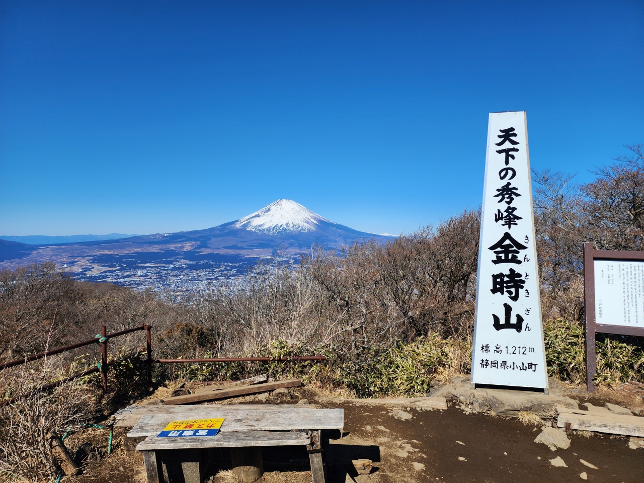
Mt. Kintoki and Hakone
I squeezed one last day trip before my four weeks were over by hiking up Mt. Kintoki and exploring the Hakone area, famous as a resort getaway with views of Mt. Fuji. Hakone itself can be simply reached by a couple of train rides from Tokyo. To get to Mt. Kintoki, there is actually a direct bus from Busta Shinjuku. I boarded the first Odakyu Highway Bus headed toward Hakone/Gotemba and got off at Kintoki-jinja-iriguchi.
You pass by Kintoki Shrine before starting the hike. The shrine is named after Sakata Kintoki, known more commonly as Kintaro, a famous character in Japanese folklore. He was supposedly born and raised on this mountain.
The hike itself is not that difficult, and during the winter months like when I was hiking you may be able to catch some needle ice growing out of the trail. Surprisingly I saw many more foreigners like me on this trail as well, which means it must be pretty popular on the internet.
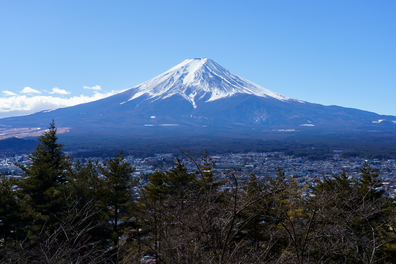
Upon arriving at the summit you are greeted by two amazing viewpoints: one of Lake Ashi and the Hakone area, and one of Mt. Fuji itself.
It only took me roughly an hour to ascend to the top of the mountain. I took a nice relaxing break up here. There’s actually a small restaurant where you can order fresh-ish food (they lug water to the top!); I ordered a shimeji mushroom miso soup, which felt great on a chilly morning.
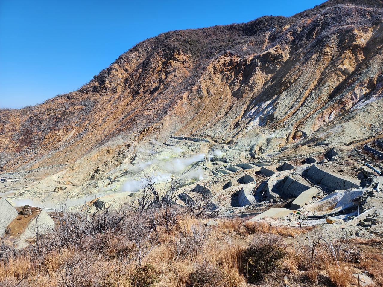
After soaking in the last close view of Mt. Fuji, I headed back down to explore Hakone. I walked to the Sengoku bus station and took a bus to Togendai Station. From here I really should have bought a Hakone day pass because things got quite pricey. I took the cable lift to Owakudani Valley to capture a glimpse of sulfur-lined fumarole vents. They are also famous for eggs with black shells, which get their color from sulfur reacting with iron in the water and depositing on the shell surface. Apparently there is a hiking trail that leads to the top of Mt. Komagatake, but it was closed when I went due to volcanic activity.
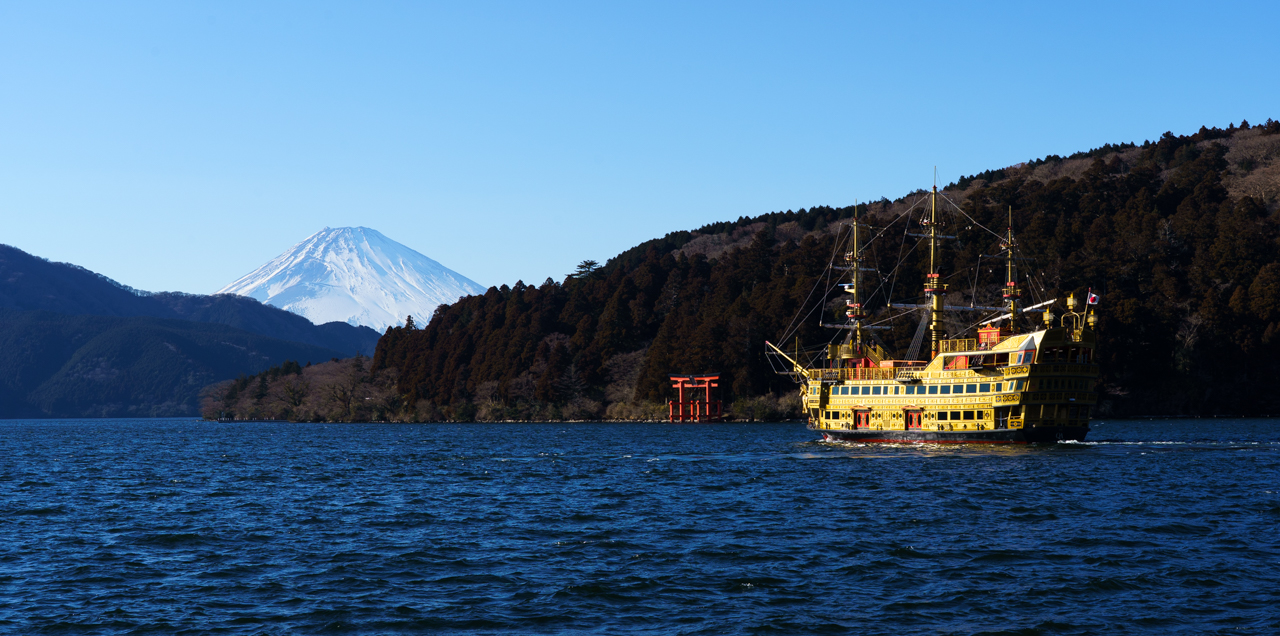
I returned back to Togendai Station to ride the Hakone Sightseeing Cruise, an overglorified boat with pirate decor. Truthfully this ride really isn’t worth it, and it runs quite infrequently for the price. Oh well, I wanted to get across the lake for a final view of Mt. Fuji with the ship and Hakone Shrine’s Torii of Peace—and it at least delivered on that front.
Unfortunately I had to rush back to Tokyo, so I didn’t have a chance to explore Hakone Shrine. I think the Mt. Kintoki hike is definitely worth it, but be prepared for slow travel times, big tourist crowds, and expensive prices if you plan to go to Hakone as well. If just doing the hike, I would consider taking the Odakyu Highway Bus from Togendai Station directly back to Tokyo. You can see my hike data here.
Daytrips I wish I had done
- Visiting Lake Yamanaka: This is the last of the Fuji Five Lakes that I did not visit. In the winter lots of swans congregate here. In February, you can also see “Diamond Fuji,” which occurs when the sun sets right at the top of Mt. Fuji.
- Hiking Mt. Ohira: Mt. Ohira is one of the closest mountains to Mt. Fuji, and as such, you get great views with Lake Yamanaka in the foreground.
- Exploring more time in Okunikko: There is so much nature to explore in the winter months in Okunikko. Particularly, you can do snowshoeing in the Senjogahara Marshland, or hike inside Unryu Valley and see frozen icicles in the gorge. Having been to Minnesota’s North Shore in the winter months, I don’t feel like I’m missing out on too much here.
- Visiting Enoshima: As mentioned above, can be combined with a Kamakura day trip.
,_reverse.png)